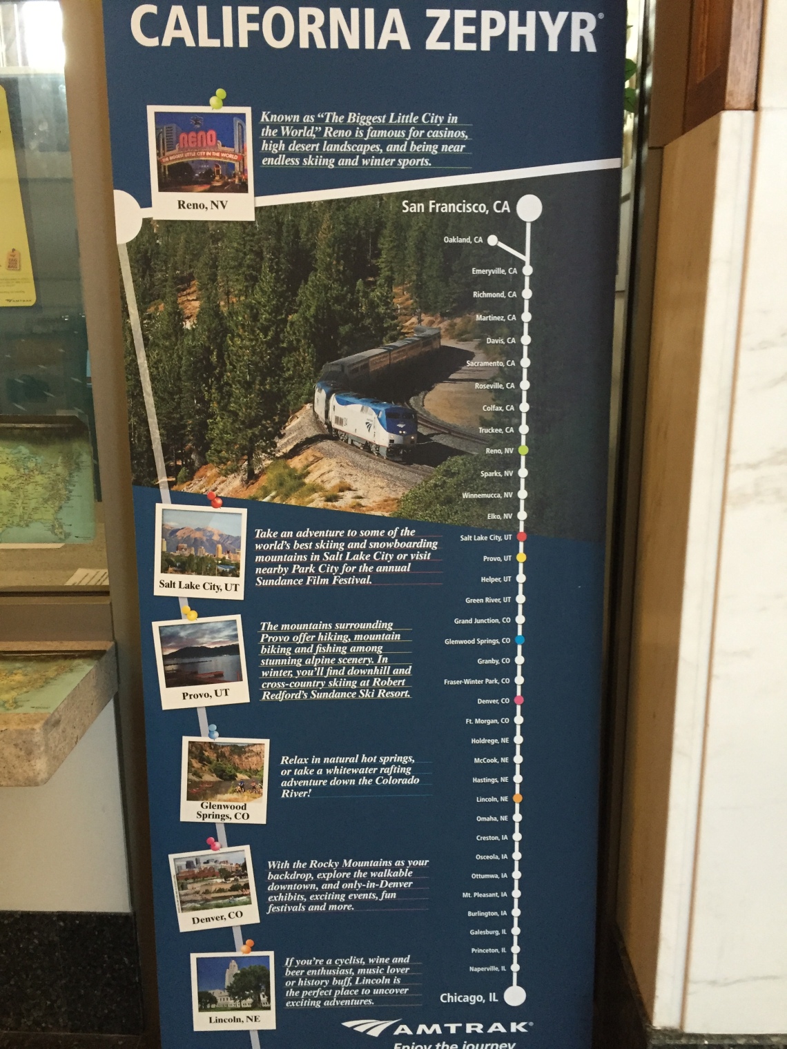
The Zephyr
California Zephyr is the Amtrak’s train that runs from Chicago, Illinois to Emeryville, California, with bus connections across the bay to San Francisco. Zephyrus means the Greek god of the west wind. True to the reputation of its name, California Zephyr traverses one of the most scenic railroad routes in North America. While taking nothing away from the scenery of the Great Plains with corn fields after corn fields or the excitement of crossing the Mississippi, the highlights of the Zephyr’s route are crossing the Rockies and the Sierra Nevada.
I was fortunate to travel on the Zephyr from Denver to Sacramento in June 2016. I flew to Denver one Tuesday evening, spent the night in Denver, and boarded the train around 9 AM (slightly behind schedule) Wednesday at the historic Union Station in Denver. The train had left Chicago the previous afternoon around 2 PM. I boarded the train leaving the “are we there yet” attitude at home. My expectations for the trip were very high after reading about the scenic beauty and the historic significance related to the California trail traveled by the pioneers during the Gold Rush years of the route from Denver to Sacramento. I have traveled on the same train from Davis (a university town near Sacramento) to Emeryville in 2000, during my school years at UC Davis. I tried my best to lower (or manage) my expectations, due to the fear of being disappointed and being bored by traveling alone. Pretty soon I realized that there was no need for that. My expectations were met and exceeded easily.

Colorado (Day 1)
The historic Union Station in Denver has been restored to showcase its splendor recently. There are restaurants, boutique shops, and even a hotel (The Crawford) inside the station.


The train was scheduled for arrival at 8:05 AM in Denver. The train arrived an hour late, but at the end of the trip I realized that Amtrak’s overall schedule is based on a thorough understanding of their own performance. I believe we reached Salt Lake City an hour late too, but reached Sacramento on time! Amtrak seems to have left plenty of float in their schedule. They run on the rail roads owned by Burlington Northern Santa Fe (BNSF) from Chicago to Denver and the rail roads owned by Union Pacific (UP) from Denver to Emeryville. The freight trains of both BNSF and UP will have priority over Amtrak on the segments of tracks owned by them. Again, leaving the “are we there yet” attitude and truly enjoying the time on the train as part of a relaxing vacation than the means to get from Point A to B are the keys to an enjoyable train trip.

The California Zephyr has the two-level Superliner cars. My car was next to the observation car, which was next to the dining car. The observation car has larger windows and a different seating arrangement with seats facing the windows and seats around small tables. The lower section of the Observation car included a café that served snacks, box lunches/dinners, and beverages (including alcoholic beverages). A very enthusiastic gentleman named Nick ran the café. His announcements every three hours about his personal 30-minute break and his assurance that “have no fear; I will be back to keep you hydrated and fed” was hilarious. The operation of the microwave kept him challenged throughout the trip with breakdowns after heating consecutive pizzas.
Amtrak offers formal dining in the dining car. One needs to make reservations to be assigned seating. Also need to be prepared to be seated with others as all tables will be attempted to be seated with four diners. The ticket for the sleeper cars cover the basic meals served in the dining car. I was traveling on the normal coach ticket (about $100 from Denver to Sacramento), and the meals were not included. Nick in the café kept me well fed and hydrated with both alcoholic (selection of draft beers) and nonalcoholic beverages throughout the trip (the iced lemon tea was very good). I will write about sleeping in the train later in this blog.

The train left Denver around 9:15 AM and traveled across Colorado’s Rocky Mountains and reached the last stop in Colorado, Grand Junction, around 5 PM. This covers around 300 miles of spectacular scenery. I spent most of time in the observation car, and limited amount of time in my assigned seat in the coach. Either way, I was glued to the window enjoying the scenery, taking a little walk inside the train, checking the café and enjoying the drinks, striking up conversations with some of the travelers in the observation car, and again enjoying the spectacular views. Taking good pictures form the train is not that easy. You need to deal with the moving train, blurry windows, and reflection on the windows. In spite of that, I kept my iPhone camera busy.


The scenery leaving Denver gets very beautiful within 15 minutes. Rolling hills soon give way to lush green valleys with snow covered mountains in the background. The train passes through the 6.2 mile-long Moffat Tunnel that crosses the Continental Divide within 2 hours of leaving Denver after climbing almost another mile higher than the mile-high city of Denver. The famous ski resort town of Winter park welcomes you when the train comes out of the Moffat Tunnel.
The next stop Granby is billed as the gateway to the Rocky Mountain National park. The Colorado Rockies were formed about 70 million years ago as the overlying sedimentary rocks and the base igneous and metamorphic rocks rose from the inland sea bottom due to tectonic forces as the Oceanic Plate slid under the North American continental plate far away near the pacific Ocean. This “pushing the rug-effect” gave rise to the Rockies resulting in mountain ranges that were as high as the Himalayas (around 28,000 ft elevation) initialy. The Canadian Rockies were formed earlier, around 90 million years ago from the present time. The Colorado Rockies have been shaped by the great forces of ice, water, and wind through various episodes of massive erosion and have almost lost half of their heights, and now rise up only as high as about 14,000 ft elevation! This erosion and the presence of both sedimentary (formed under water by deposition of primarily sand and gravel layers compressed into rocks) and metamorphic rocks (shaped by heat and pressure due to tectonic forces) make the landform along the Colorado’s Rockies very beautiful and interesting.
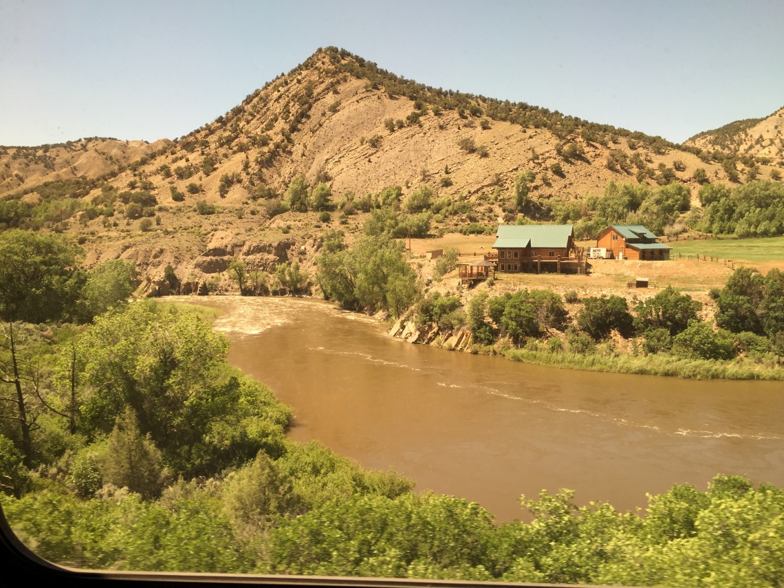

Train pulls into Glenwood Springs, another famous ski resort town, mid-afternoon after lunch. One can get down at stops to take a walk on the platform for few minutes. Be warned that you may struggle to stay out of the congregation of smokers near the train!


Leaving Glenwood Springs, the train begins the 20-mile trip through the winding De Beque Canyon within an hour to reach the town of Palisade. Train reaches Grand Junction, the last stop in Colorado around 5 PM. After Grand Junction, the green scenery gives way to more brown, but equally impressive with sandstone “castles and monuments” cast by the great forces of nature.


Utah (Day 1 and Night)


The train reached Green River, the first stop in Utah around 7 PM.


We arrived at Helper, UT around 8:30 PM. The town’s name comes from railroading in the past where helper engines were needed for the West-bound trains to climb the Wasatch Plateau to Soldier Summit. The climb to Soldier Summit will take the train again over 7,000 feet elevation, over a 2,000 ft climb from Helper. At this time, the train has traveled over 440 miles over 11 hours during the day. The sun was going down and time for dinner and devise a plan to at least get some hours of sleep on my coach seat.
I would definitely recommend a sleeper car roomette if you traveling with family, especially children. You will have the use of a shower and seats that can be converted to bunk beds to lay down and stretch out. In addition, the ticket covers the basic dining plan. The ticket may be 4 to 5 fives times more expensive than the coach seat. Another disadvantage is that if you do not venture out to the observation car, your view may be limited to one side of the window. As the train winds up and down the mountain ranges, the side with the best view changes all the time. I would like to refer you to the useful links at the end of this blog for more information about the train, dining, bathroom facilities, and sleeping arrangements.
Back to my efforts (and some fellow passengers) of trying to sleep on the coach seat. I must confess that I do not sleep well even in hotels, so please take my comments with a grain of salt. There were several who seemed to be sleeping soundly. Amtrak seats are way better than airplane seats, and can be reclined to 60 degree angle and have adjustable footrests. Almost every hour, I was getting up and walking quietly trying to find a better spot with two adjacent seats that are vacant in the observation car to stretch out better. This lasted only until a hand rest or a foot rest started hurting me bad enough to move again.
I managed probably about four hours of sleep here and there. I was awake as the train pulled into Salt Lake City few minutes past mid night. I have visited Salt Lake City before, but missing the scenery around it is a compromise for this train schedule that is based on daylight viewing times of the Rockies and Sierra Nevada. I do not recall the stop at Provo, UT before the stop at Salt Lake City. I must have been asleep. Provo is the home of the Brigham Young University.
Nevada (Day 2)

I was up at 5:15 AM to watch the sun rise over the Nevada desert. My iPhone has also changed to Pacific time from Mountain time during the early morning hours. We have passed the stops at Elko (NV) dubbed the “last real cow town in the American West”. We were at a place called Golconda, with the our next stop at Winnemucca (NV) approaching. I-80 was paralleling the rail road, and continued more or less till reaching Sacramento from this point. Scenery included desert and brown mountains.


We arrived at Reno, the “Biggest Little City in the World”, around 8:30 AM. The home of several casinos and the University of Nevada, Reno. I have been to Reno several times when I was a student at Davis. Usually the drive from Reno to Sacramento can be completed in 2 hours along I-80 (of course, not in winter in the middle of a snow storm though). I was wondering why the train leaving around 8:30 AM from Reno will only reach Sacramento around 2 PM. Nick at the observation car quickly explained me that it is due to the steep climb over the Sierra Nevada to almost over 7,000 ft elevation and the following long descent to Sacramento to almost near sea level will be done very slowly by the train.
California (Day 2)

From Reno to Sacramento, two volunteers from the California State Railroad Museum narrated the history of the Sierra Nevada and the building of the railroad. This route goes through the original route of the transcontinental railroad. The docents were in the lower level of the observation car. One needs to be in the observation car to enjoy their narration, done with passion and dedication. They seem to know the history of each and every railroad cut along the way!
The rail route from Reno to Sacramento is very rich in history and beauty. The history is related to the path traveled by the pioneers and during the “Gold Rush” as well as the building of the transcontinental railroad. I will cover this briefly in the subsequent sections.
Even though the origins of the geologic history of the Sierra Nevada may be very old (in geologic terms), the Sierra Nevada that we see now started “stretching” in an East-West direction about 20 million years ago. Less than five million years ago, the range that we now know as the Sierra Nevada began to rise along its eastern margin, thus making it one of the “youngest” mountain ranges. However, the granitic rocks that form the backbone of the mountain range may have formed initially 70 to 90 million years ago. The erosional forces, including those of the glaciers left their mark on the shape of the Sierra Nevada mountains.


After passing Truckee, the train started approaching the historic Donner Lake. The beauty of the scenery along the Donner Lake and Donner Summit may be covering the sad history of the area during the Gold Rush years. Quoting Amtrak’s California Zephyr’s train route guide, “on the right side of the train is where the famed Donner Party, traveling west from Illinois, was stranded during the winter of 1846-47. Some of the party of 87 resorted to cannibalism; only 48 survived. After passing the lake, the California Zephyr passes through a series of snow sheds that protect the track from being blocked by the more than 30 feet of snow that falls in the typical winter.”

Train continues its slow climb and reaches the tunnel through Mt. Judah some 7,000 feet above sea level, the peak point of the climb across the Sierras. After that the train starts its slow descend towards Colfax, passing the Emigrant gap on its way. The pioneers were believed to have lowered their wagons on ropes to control the descent along these steep hills during the Gold Rush years.

Auburn is located between Colfax and Roseville, and near Sutter’s Mill where the discovery of gold led to the “California Gold Rush”. Gold was discovered here in 1848, leading to the rush next year by the “49ers”. Several of these prospectors settled down in Roseville.
The train slowly pulled into Sacramento, the state capital, around 2 PM, 15 minutes ahead of schedule! The train journey from Denver to Sacramento covered 1,315 miles in about 29 hours and across some of the most beautiful scenery in the country. The key to enjoying the trip is to relax and not wonder about when we will reach the destination. The California Zephyr is THE destination!
Tips for the Train Trip
- Do not schedule a time sensitive appointment at your destination based on the train schedule. Leave more than several hours of cushion, so you can travel relaxed.
- If traveling with children or over two nights, seriously consider booking a sleeper car.
- Read the Amtrak travel guide about the route, so you can relate to the places you pass. Other than from Reno to Sacramento, there are no regular announcements about places of interest (yes, they did announce the Moffat Tunnel…but did not mention the continental divide).
- Internet and phone services will not be available for most of the route, other than near towns.
- Check out some of the links below, which cover the travel aspects in more detail.
- Consider the Zephyr as the destination and a key part of the vacation.
Useful Links:
- https://www.amtrak.com/ccurl/692/258/Amtrak-California-Zephyr-Train-Route-Guide-2014.pdf
- https://www.amtrak.com/ccurl/836/828/California-Zephyr-Schedule-011116,0.pdf
- https://www.amtrak.com/ccurl/938/664/California-Zephyr-Dining-Menu-eastbound-train.pdf
- http://www.onefootonsand.com/california-zephyr-capitol-limited/
- http://www.seat61.com/california-zephyr.htm#.V3mZb8H6uUk
- https://www.youtube.com/watch?v=oi40dooQwYg
